Scientists construct models to gain understanding of natural phenomena in the world. Such models can adopt a variety of shapes and representational styles, from physical scale models to highly idealized mathematical models, depending on the target investigated and the epistemic and non-epistemic goals that motivate their construction. The aim of this project is to examine how scientists make “model judgments” in their practices, that is, how they formulate model-target comparisons and reach agreements about the most adequate representational resources to build fruitful models. The specific focus of the project is the formation and standardization of “model judgments” in geodetical modelling practices in the nineteenth and early twentieth century. Special attention will be given to the role of “judgments of similarity” and the introduction of idealizations in the production of geodetical maps. With the help of the “Measuring the Earth: Digital Repository for the History of Modern Geodesy” in Dept III at the MPIWG, the project looks at the proceedings, minutes, and annual reports of the International Association of Geodesy (and its precursors the Mitteleuropäische Gradmessung, Europäische Gradmessung, and the Internationale Erdmessung). This project is part of the “Art of Judgment” working group (Dept. III), and engages with the research aims in digital humanities of the “Measuring the Earth” project (Dept. III).

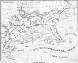
German levelling network 1879. Trigonometrische Abteilung der Landesaufnahme / Public domain, see Wikimedia Commons.