This project aims to provide an open repository of primary sources for the history of late modern geodetical research. Moreover, it will study the application of digital methods to the historical analysis of international cooperation, scientific diplomacy, and interdisciplinary debate in the field.
The primary goal of the project at this stage is to make the materials produced by the precursors organizations of the current International Association of Geodesy available for digital inquiry through a digitization process made possible by a cooperation between the libraries of the MPIWG and the GFZ in Potsdam. Metadata for the whole corpus and a growing bibliography of its component elements are available on our Zotero group. You can request access to the corpus by sending us an email.
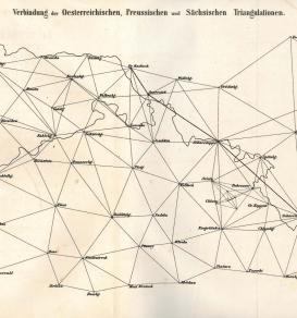
The first of these entities, the Mitteleuropäische Gradmessung, was set up in 1862 as an intergovernmental association, following a proposal by the Prussian military surveyor Johann Jakob Baeyer, to initiate the exact measurement of degrees of latitude and longitude across Central Europe and promote scientific geodesy. Over time this regional association developed into a truly global endeavor, leading it to be first renamed Europäische Gradmessung (1867) and then Internationale Erdmessung (1886).
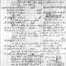
Between 1862 and 1912 the association has produced a variety of printed material, such as conference minutes and research reports, giving shape to a thematically coherent, multilingual corpus of more than 15,000 pages. Based on the digitized material we will evaluate different methods for corpus analysis and distant reading to develop appropriate ways to study and interpret these types of sources.
One aspect that is of particular interest from the point of view of digital humanities research is the issue of how to foster automated analysis of multilingual corpora, a crucial issue in the digital history of science for the age before the advent of global English (Gordin 2015).
Among possible developments of this project at later stages are the interlinking of the digitized material with other existing repositories that hold relevant geodetical publications (such as, for example, JSTOR) and the comparative analysis of other series of geodetical research reports (such as, for example the annual reports of the US Coast and Geodetic Survey).
As a way to frame the project in the broader historiographical debate we hold also an open discussion group. See the details in the upcoming events below.
Feel free to get in touch if you want more information or want to get involved in the project or the discussion group.