Meandering Mississippi. Map by Harold N. Fisk, U.S. Army Corps of Engineers, 1944 | Geological Investigation of the Alluvial Valley of the Lower Mississippi River project_anthropocene_hkw_meandering_mississippi_map_harold_n_fisk_imgsize_buehne

Meandering Mississippi. Map by Harold N. Fisk, U.S. Army Corps of Engineers, 1944 | Geological Investigation of the Alluvial Valley of the Lower Mississippi River.

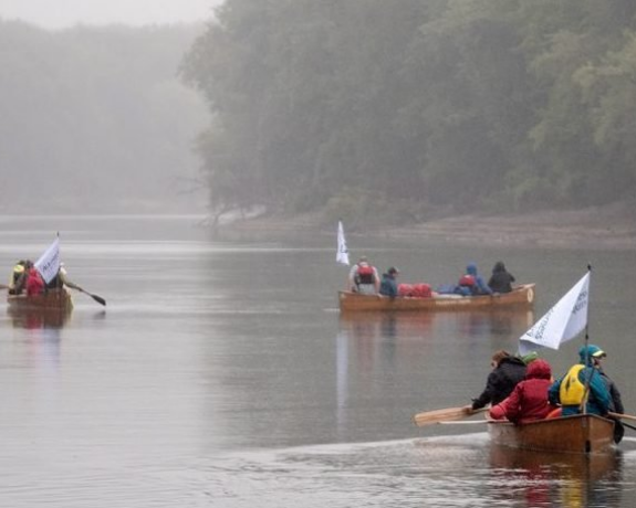
Mississippi. An Anthropocene River explores the vast region encompassed by the world’s fourth largest river. The project’s aim is to make this landscape legible as a critical zone of habitation and long term human-environment interaction. It analyzes the Anthropocene on the ground and in the field, exploring ground-truths to augment the remote-sensing operations and abstracted knowledge of global Anthropocene science. The project is manifest in a variety of field-research activities, public forums, workshops, and journeys on and along the Mississippi River. Until November 2019, several interdisciplinary groups of researchers, artists, and stakeholders from civil society will investigate the river basin to develop local approaches to issues of planetary change and together will forge new methods for transdisciplinary research and education. The project is developed and organized by Haus der Kulturen der Welt (HKW) and the Max Planck Institute for the History of Science (MPIWG).

Why the Mississippi River Region?

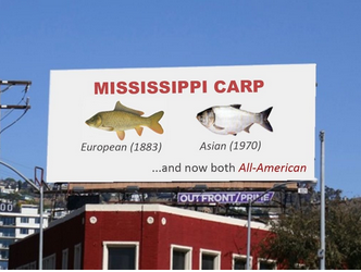
The Mississippi River’s meandering path has carved out an iconic place in US mythology and has come to symbolize the vicissitudes of human-environmental relations. Originally more of a floodplain than a river, in the 20th century an ambitious dredging program transformed its tributaries into a riverine form. Its ecology has evolved as a constantly shifting ecosystem, a catchment of cultures, a dividing line, a water highway for resources and goods, and a sink for pollutants. From logging and mining zones in the Upper River area to the high technology and petrochemical refineries in the Delta; from the industrial agricultural landscapes of the Midwest to the “dead zones” of the Gulf of Mexico; from the historic transportation network enabling the egregious transport of slave labor and cotton to the social injustices of poverty and deindustrialization today—the Mississippi is a symptom of and object for investigating the radical impact humans inflict upon the Earth.

The Mississippi River region therefore presents a rich example for understanding how abstracted scientific concepts, such as the Anthropocene, are manifest in the everyday lives of those affected by them. The flows of people, commercial goods, toxins, extracted materials, and histories that the river draws together demonstrate the interdependence of ways of life, the environment, and the sociopolitical realities that have become entwined by its path through the American continent. The river serves as an ideal setting to investigate what the Anthropocene means at a human and local level by framing large-scale ecological changes as they are manifested in situ.

News & Press

The Anthropocene Review publishes two Special Issues on Mississippi. An Anthropocene River project

More

Department I Project "Mississippi: An Anthropocene River" featured on Österreich 1

More

3Sat reports on the Mississippi Project in cooperation with Haus der Kulturen der Welt

More

Multimedia


Five Anthropocene River Field Stations

The objective of the project "Mississippi. An Anthropocene River" is to make this landscape legible through field-oriented explorations of anthropocenic transformations. It unpacks the sources of and impacts on the distinctive ecologies and social realities at the regional level—utilizing five Anthropocene River Field Stations located along the river from Minneapolis to New Orleans, to investigate, highlight, and share historical and contemporary issues of the respective regions using both scientific and artistic research methods over the course of one year.


Anthropocene River School (Spring & Fall 2019): St. Louis & New Orleans

In the spirit of continuous curricular development fostered by the Anthropocene Curriculum initiative, the Anthropocene River School is a further component of the project intended to focus on educational aspects both online ("Open Seminars“) and at selected field site events ("Field Campus"). Drawing on empirical and qualitative data gathering, the River School will integrate the work of the Anthropocene River Field Stations and transform the research materials into an ongoing, collaborative teaching enterprise. In its public presentation the River School will introduce opportunities for meaningful participation (teaching and learning) from people around the world, exploring how the Anthropocene is playing out on the ground in different settings.


An Anthropocene River Journey (Fall 2019): Field-oriented Explorations of Anthropocenic Transformations

In fall 2019 a group of students and researchers will take an “Anthropocene River Journey" largely by canoe, traversing the Headwaters down to the Gulf of Mexico, developing a synoptic understanding of the river as a whole and collating research and observations drawn from the entire length of the river.

project_deptrenn_anthropocene_mississippi_river_semester_2019.png
Canoeing the Mississippi River.

Within these activities, scholars from many fields, along with experts, artists, and activists, are working to develop transdisciplinary practices that can speak to the multifaceted nature of the problems faced en route and the many vernaculars through which the Anthropocene is expressed. Traveling participants will carry out their own research and provide extensive documentation, bringing the findings downstream and tying the different narratives together.


Anthropocene River Campus: The Human Delta (November 9–16, 2019)

Finally, a one-week “Anthropocene River Campus,” will be held in New Orleans to mark the summary of the project, informed and leveraged by the research work of the Field Stations. Throughout the fall, the project and its findings will be presented and discussed on a tailor-made online platform.

Meandering Mississippi. Map by Harold N. Fisk, US Army Corps of Engineers, 1944 | Geological Investigation of the Alluvial Valley of the Lower Mississippi River.