In the middle decades of the twentieth century, a group of geomorphologists and hydrologists in the United States set out to revolutionize the science of rivers and landscapes. Instead of situating rivers within narratives of long-term landscape evolution, as their own mentors had done, they sought to model them as physical systems in equilibrium. To do so, they required new instruments, new forms of data, and new mathematical techniques, many of them drawn from physics and engineering. They also required new kinds of relationships to rivers and watersheds, to the people who lived with and on them, and to the politicians who sought to govern them. At a period when dam-building and other efforts to engineer rivers were reaching an almost frenzied peak, these scientists hoped that new methods and relationships would amplify their voices in debates over the future of rivers in the United States, as well as in US-supported international development projects. This project investigates the scientific, environmental, and political implications of the rise of quantitative geomorphology in the decades following World War II, a time when many branches of the Earth sciences were undergoing similar changes. It is part of a broader investigation of how methods and theories in the Earth and environmental sciences have been linked to visions and practices of collective life.

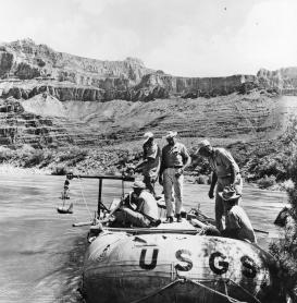
Scientists preparing to measure the flow of the Colorado River in the Grand Canyon National Park, Arizona, 1965. Photographer: Luna Bergere Leopold, U.S. Geological Survey. Published as Figure 86 in U.S. Geological Survey. Professional Paper 669-D. 1969.
Project
(2022-)
