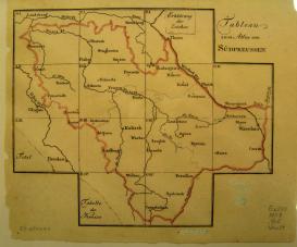
In 1793 the Prussian government conducted a survey, called the Indaganda (things which must be hunted or tracked down), of towns in the province of South Prussia, acquired in the Second Polish Partition of the same year. This project uses the survey as a nodal point in the administration’s efforts to use data as a way of knowing its colonial spaces. What had been dispersed information assembled from local projects before 1793—including for water management, weights and measures, and building practices—became after 1793 more systematized forms of knowledge inscribed in printed format and circulated for policy, practice, and training.
After 1793 an information order of the Prussian frontier—the space of the Polish Partitions—can be discerned, one comprised of data organized into forms of knowledge suited for governance and development. A notable feature of this information order was the visual aesthetic it created for training the eye in how to view the partition space. The creation of this information order was a crucial turning point in the evolution of the Prussian bureaucracy as it became more scientific and technical, and as its technical administrators became more rule-bound to their self-defined best practices and the behaviors characterizing these.