Ptolemy’s Geography (second century CE) contains a catalog where localities are listed with their geographical coordinates, as well as concrete instructions, which allow anyone to draw maps of the known world.
In a joint project with Professor Alfred Stückelberger (Institute of Classical Philology, Bern), a new edition of Ptolemy’s Geography has been published in 2006. It is a revised edition of the Greek text, which—for the first time—considers the manuscript found in Topkapi Museum in Istanbul in 1927, and includes a German translation and a reproduction of the maps. The publication of the 2006 edition of the Geography was the basis of new investigations on Ptolemy’s sources and working methods, carried out at the University of Bern and continued at the Excellence Cluster Topoi, Berlin. It has led to a better understanding of the origins of the geographical coordinates contained in Ptolemy’s work and of the textual transmission of the Geography.

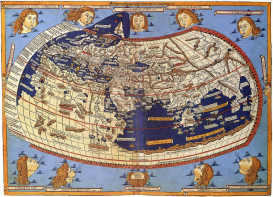
A printed map from the fifteenth century depicting Ptolemy's description of the Ecumene, (1482, Johannes Schnitzer, engraver). Source: Wikipedia Commons.
The research project investigates the genesis of Ptolemy’s geographical catalog of places, in particular by considering its structure and the relations between the text of the Geography and its cartographical realization. Understanding Ptolemy’s working methods does not only shed light on the scientific practices in Antiquity; it enables also to set up new criteria for philologists to assess whether a coordinate in a manuscript is likely to be the original or has been corrupted during the transmission of the text. Three aspects will be hence analyzed together: the origins of the catalog, the history of its transmission, and reconstruction of Ptolemy’s maps.
Tools developed in the frame of computational humanities enable us to take advantage of these particularities of Ptolemy’s Geography that are obstacle to more traditional approaches: the large amount of numerical data, the complex structure of the catalog, the deep relations between the coordinates, and their graphical application. Thanks to computable documents such as Jupyter notebooks, it is possible to perform a great variety of analyses, to widen the scope of the philological investigation and to communicate the results in form of digital documents. The case studies that are examined relate to Ptolemy’s description of the Iberian Peninsula. This research project aims, among other things, at the realization of an enhanced, digital, interactive edition of Ptolemy’s map of the Iberian Peninsula and its catalog of localities.