Models and sketches provide a way of transmitting practical knowledge across distances without personal contact. Their role in Chinese history is unclear. On the basis of various resources, this project investigated technical heuristics in China, the history of three-dimensional modelbuilding and the application of construction drawings in craft culture.
Furthermore, selected processes of procedural and idiosyncratic inventions and innovations and case studies scrutinized:
- The environment that generates invention, and
- Tracked how a technology is distributed in materia in premodern China.
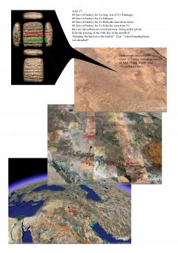
These were used as a base to Geo-reference historical materials using the Google Earth/maps platform. Material drawn from various image or text related databases are presented chronologically in space and in relation to another. Existing geo-referenced databases can be uploaded, new ones created; individual historical materials such as maps, sketches etc., and commentaries can be added by the user and projected on this surface. The example shows the assembly of data from various databases concerning the city of Jizhou in the thirteenth century:
- Harvard CHGIS database displaying administrative points and borders (including rivers, etc.) from 200 BC until AD 1997
- Extract of the database on the Location of Buddhist Temples in China (fifth to seventeenth century)
- Extract of the database on craftsman marks (eleventh to eighteenth century) compiled by the Independent Research Group, including photographs of the objects.
Easy handling was a major aim of the tool. Databases are selected and deselected with checkboxes.