My project for the Local Gazetteers workshop (July 2017) collects and analyses information on "Making Mount South as the Front Gate." Mapping the chronological and spatial distribution of the data on this topic enables us to get a general picture of this planning tradition, which will help us to understand city planning in ancient China in the scope of the History of Science and Technology. This research is an extension of my doctoral dissertation and the result is about to be published as a journal article.
"Making Mount South as the Front Gate" is an important method of deciding the central axis in city planning in ancient China. It was first recorded in the Shiji that the First Qin Emperor used the "Mount South" to determine the location of the new palace, Epang. Since then, the method was passed down as similar recordings re-appeared in subsequent dynasties, despite dramatic changes in the geography of the political centers. In addition, according to the local gazetteers, the tradition expanded from capital cities to local cities.
My approach to the workshop is to search for the keywords "Mount South + Gate" in the database, to analyze the data and display the results based on GIS. Next, some typical cities will be picked out to explore the principles of choosing and landscaping "Mount South." Finally, considering the characteristic of "modelling heaven and Earth" in city planning in ancient China, the research aims to discuss the astronomical image of "Mount South."
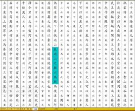
The earliest recording of "making the peak(s) of Mount South as the Front Gate (of the city)", a screenshot of the Shiji, Vol.6, p.134 from the database Zhongguo Jiben Gujiku, published by Beijing Erudition Digital Research Center.
Project
(2017)
The Tradition of "Making Mount South the Front Gate" in City Planning
Publications
Xu, B. (2019). Making mount south the front gate: research on the Ancient City planning method based on the Local Gazetteers digital platform [表南山为阙:基于地方志数据库的古代城市规划方法研究]. In Proceedings of National Planning Conference 2019 [2019中国城市规划年会论文集] (pp. 7-24). Chongqing: Urban Planning Society of China [中国城市规划学会]. doi:10.26914/c.cnkihy.2019.015135.
Read More